Expedition data:
Duration of expedition: 35 days (September - October 2000)
Road traveled: 9909 km (6,157 miles)
Surveyed provinces: Manisa, Izmir, Aydin, Mugla, Denizli, Afyonkarahisar, Usak, Kutahya
Recorded visual data: 1085 shots of analog photograph, 970 shots of digital photograph (560 Mb), 22 hours of video
Archaeological Data:
Archaeological periods surveyed: Palaeolithic/Epipalaeolithic, Neolithic, Chalcolithic and EBA
Number of target settlements: 204
Distribution of archaeological periods over target settlements: Palaeolithic/Epipalaeolithic: 6, Neolithic: 13, Chalcolithic: 20, EBA: 120, Chalcolithic + EBA: 22, Neolithic + Chalcolithic + EBA: 7, Neolithic + EBA: 5, Other: 11
Distribution of settlement types over target sites: Mounds: 148, Cemeteries: 9, Flat settlements: 5, Single find-spots: 4, Mounds with cemeteries: 4, Artifact scatters: 3, Caves: 3, Flat settlements with cemeteries: 2, Slope settlements: 2, Habitation sites /Ateliers: 2, Other: 22
Number of sites not visited: 16 (Sites in military zones; completely demolished sites; sites presented just by name in publications)
Number of non-documented sites: 8 (Sites with scarce description of location; sites utterly destructed by agriculture or by modern settling)
Number of documented sites: 180
Destruction Data:
Number of documented sites subject to destruction: 139
Distribution of types of destruction over documented sites: Agriculture: 71, Contemporary settlements: 29, Illicit digging/treasure hunting: 23, Highways, roads, bridges etc.: 8, Natural causes: 2, Mines/quarries:1, Other: 5
Types and description of destruction by district:
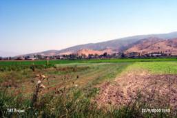
Aegean Coast: The main factor in destruction of archaeological sites is agricultural activities with a rate of almost 70% within the coastal district. Contrary to popular belief and although several large cities like Izmir, Manisa, Aydin and Mugla populate this area, settlement activities and illicit digging are to be blamed only for a small percentage of the destruction for the northern and middle parts of this region. However, modern settlements as a primary cause of destruction becomes pronounced toward the southern tip of this region. (e.g. Mugla).
Aegean Inland: Cultivation and other agricultural activities comprise the highest rate of destruction with 52%. Illicit digging is the second important factor followed by modern settlements and construction activities. Though rare, usage of archaeological sites as modern cemeteries and construction of dams are other causes of damage. |
|
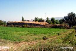
Samples from Visual Documentation of Destruction
|
|
|
 |
Akirbey Ciftlik (mound): c. 5,000 years old. Early Bronze Age (EBA) settlement. The mound, with village houses, barns, pens etc. on its northern slope, lies in a territory of Hellenistic/Roman ruins. |
 |
Altintepe (mound): c. 5,000 years old. EBA settlement. Most of the mound's deposit is destroyed as a result of agriculture and terracing. |
 |
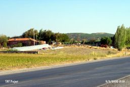
Basmakci (mound): c. 5,000 years old. EBA settlement, with a school building on the left and apartment blocks on the right which cover almost the entire surface of the mound. It was once planned to construct a highway through the mound. Though it seems that such plans are suspended for now. |
 |
Beycesultan (mound): One of the most important Chalcolithic and EBA sites in the Aegean Region. A crucial reference point for Aegean Prehistory and Protohistory. Drainage channels pass through its eastern and southern skirts, a monumental tomb dating back to the 13th century AD (Behice Sultan Turbesi) sits atop. Although an officially certified archaeological site, the mound excavated in the sixties is subject to illicit digging now. |
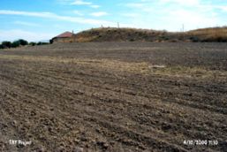 |
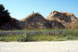
Bozan (mound): c. 5,000 years old EBA settlement. Almost half of the mound is cut off and its soil removed and used for highway construction in 1996. It is partially leveled to the ground and is being used as dumping ground. The northwestern sector is being cultivated and village houses are built on the northeastern skirts. |
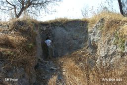 |
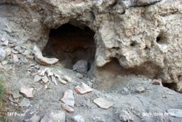
Bozkoy Hoyucek (mound): c. 5,000 years old EBA mound. Although officially certified as an archaeological site, the eastern section of the mound bears a deep crevice dug by a grader for treasure seeking. |
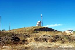 |
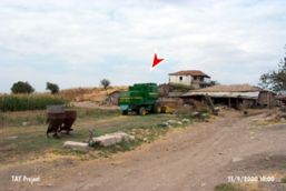
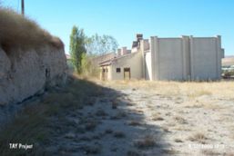
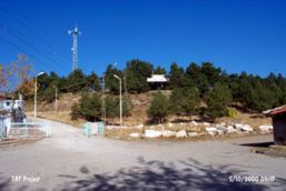
Cobanlar Kadiyuk (mound): EBA. A broadcasting station, a TV/radio transmitter, power towers on the top and a house on the southern slope. The eastern sector cut away by the municipality. |
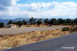 |
Esikcitepe (mound): A broad and shallow mound dating back to the EBA. An olive orchard, a small house, a barn, and a hayloft lies atop; a single-flat building (probably a depot) right on the skirt. The northern slope is terraced. |
 |
Egret/Maltepe (mound): A 28 years old military cemetery sits atop this c. 5,000 years old EBA mound. Numerous illicitly dug pits on all slopes. |
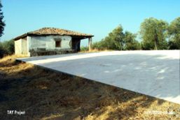 |
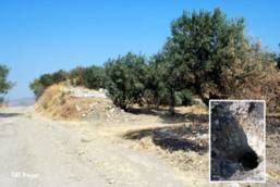
Hacirahmanli (mound): c. 7,000 years old Chalcolithic Age mound, settled again in the EBA. 300 sq. meters of its surface is covered by a cement platform used for processing grapes. A house sits to the south with vineyards on the slopes. |
 |
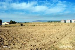
Hamidiye/Nazilli (mound): Neolithic Age settlement is entirely demolished, all of its soil removed and used for who knows what... |
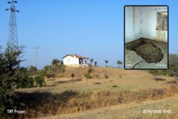 |
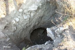
Hasattepe (mound): An EBA mound with numerous illicit digger pits one of which is dug below the living room of the house built on top of the mound (small photograph). The western slope is leveled for agricultural purposes. |
 |
Helvaci Hoyucek (mound): The uneven surface formed by pits and heaps of soil is the result of illicit digging that scattered the archaeological strata severely. The soil from the mound was also removed and used in the construction of the road passing through the west. |
 |
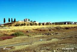
Karaoglan Mevkii Hoyugu (mound): The deposit of the mound and the bedrock it lies on are cut away on the western sector in order to build the petrol station. A village house sits on the north east section. Cultivated fields cover the eastern slopes. Intense modern settling is observed to the west. |
 |
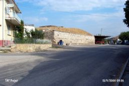
Kavaklikahve (mound): This seriously damaged mound bears cultural deposits from c. 8,000 BP to 2,000 BP. Half of it is razed down to enlarge the agricultural fields. A deserted house, a power pole and numerous illicit digger pits can be found atop and around. |
 |
Kizciftligi/Trikopi (mound): c. 5,000 years old EBA mound with a bereft farm on the top. Surrounding summer houses are threatening the integrity of the site, the skirts of which are partially destroyed already. |
 |
Kocagentepe (mound): A Chalcolithic Age mound disguised as a farm complete with the house, the pen, the greenhouse and the melon fields... A deep crevice dug to plant trees runs through the western slope. |
 |
Lembertepe (mound): Chalcolithic Age mound. Kusadasi - Menderes highway cuts through the middle of the mound and the sections left on both sides are covered by greenhouses and cultivated fields. |
 |
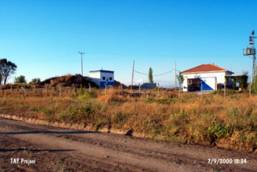
Mecidiye (mound): Modern village houses lie atop the mound surrounded by walls and other buildings. |
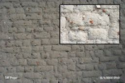 |
Mecidiye (mound, detail): The soil of the mound with archaeological inclusions is used as construction material for the modern village houses built right on top the mound. |
 |
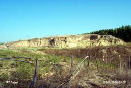
Subak (mound): A huge destruction pit on the northern slope; the surface cultivated; the eastern, northern and western slopes completely cut away... |
 |
Toygartepe (mound): A large EBA mound with a tumulus atop. The eastern slope is razed parallel to the road and the irrigation channel running alongside. A fissure, over 40 m of length along the northeast-southwest axis was dug by bulldozers under official sanction with permit! Later on, deeper pits were illicitly dug into the fissure. |
 |
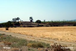
Usgebi (mound): The southern and the southeastern sectors of this c. 5,000 years old EBA mound are completely destroyed for cultivation. |
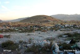 |
Sahitler/Afyonkarahisar (mound): Houses on the northwest, highway on the east, city dump on the north and the east... There lies the mound! |
 |
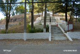
Suhut Hisar Hoyuk (mound): This mound is completely buried under a recreational park. |
 |
Yeni Yeldegirmeni Tepe (mound): A water reserve consisting of two structures built on top and a country road cutting through the EBA settlement from west to south have almost completely destroyed the mound. |
|
|
|
 Tanindi, O. - M. Özbasaran et al., 2001, Archaeological Destruction in Turkey 2000 – Marmara and Aegean Regions, TAY Project - Scientific Reports Series 1/Eng, ISBN 975-6637-01-3, Istanbul. Tanindi, O. - M. Özbasaran et al., 2001, Archaeological Destruction in Turkey 2000 – Marmara and Aegean Regions, TAY Project - Scientific Reports Series 1/Eng, ISBN 975-6637-01-3, Istanbul.
|
|