 |
Expedition Data:
Duration of expedition: 120 days (June-October 2002)
Road traveled: 20027 km (12,444 miles)
Surveyed provinces: Aksaray, Ankara, Çankiri, Çorum, Eskisehir, Karaman, Kayseri, Kirikkale, Kirsehir, Konya, Nevsehir, Nigde, Yozgat.
Recorded visual data: 2111 shots of analog photograph, 5026 shots of digital photograph (2802 Mb), 60 hours of video
Archaeological Data:
Archaeological periods surveyed: Palaeolithic/Epipalaeolithic, Neolithic, Chalcolithic and Early Bronze Age.
Number of target settlements: 627
Distribution of archaeological periods over target settlements: 31 Palaeolithic/Epipalaeolithic, 40 Neolithic, 88 Chalcolithic, 405 EBA, 11 Neolithic + Chalcolithic, 47 Chalcolithic + EBA, 5 Neolithic + Chalcolithic + EBA, 24 Other
Distribution of settlement types over target sites: 498 Maund, 31 Single find-spots, 25 Flat settlements, 22 Slope settlements, 16 Habitation sites/Ateliers, 6 Artifact scatters, 4 Cemeteries, 2 Rock shelter, 1 Caves, 22 Other
Number of sites not visited: 64 (Sites in military zones; completely demolished sites; sites presented just by name in publications)
Number of sites not documented: 48 (Sites with scarce description of location; sites utterly destructed by agriculture or by contemporary settlements)
Number of documented sites: 515
Destruction Data:
Number of documented sites subject to destruction: 439
Distribution of types of destruction over documented sites*: 149 Agriculture, 83 Contemporary settlements, 83 Illicit digging/treasure hunting, 55 Illicit digging+Agriculture, 22 Agriculture+Contemporary settlements, 17 Illicit digging+Contemporary settlements, 15 Highways, roads, bridges etc., 12 Natural causes, 2 Mines/quarries, 1 Dam.
Types and description of destruction by district:
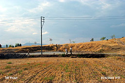
The majority of archaeological destruction in the central Anatolia region is caused by various forms of agricultural destruction. Especially in the southern parts of the region (the provinces of Konya and Karaman), attempts to enlarge agricultural fields continue to damage archaeological settlements. In addition, contemporary settlements have been built directly on top of, or on the slopes of mounds, and locals use soil taken from these mounds to repair their homes and build new ones. This illustrates the growing levels of destruction caused by building activity. The placement of features such as water towers and high voltage power lines directly on top of archaeological settlements furthers the irreversible damage dealt to cultural heritage sites. The uncontrolled building activity which continues to be damaging around the provinces of Ankara, Aksaray, Niğde and Konya is among the most important issues demanding attention in this region.
Throughout the central Anatolia region, especially in the vicinity of Eskişehir, incidences of looting and unlicensed excavations are much more common than in the rest of the country. Such destruction prevents any possibility of future systematic archaeological efforts at these settlements. This habit of the locals, which they look upon as a passion and call a ‘sickness’, is usually carried out when the harvest is complete, and hardly anyone passes by the fields and mounds. The efforts of the Gendarme to photograph and archive the archaeological settlements within the boundaries of the province of Eskişehir, we hope, will be among the important efforts to preserve this heritage.
*Clarification of primary causes of destruction:
Agriculture: All kinds of agricultural activity (cultivation, terracing, leveling, soil removal, irrigation channels etc.) on and around the mounds.
Contemporary settlements: Houses, hotels, recreational areas and holiday complexes, petrol stations, factories, dams, power lines, pipelines, cemeteries etc. built directly on the mounds.
Illicit digging/ treasure hunting: By locals and smugglers.
Mines/quarries: Stone, sand and lime mining on and around the mounds.
Highways/roads: Highways and country roads passing over or through archaeological sites, bridges built upon sites and soil removal from the sites to be used in the construction of such.
Natural causes: Earthquakes, forest fires, soil erosion, riverbed reformations, floods etc.
Other: Antique settlements, tumuli etc.
|
|
|
|
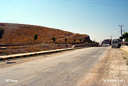 |
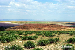
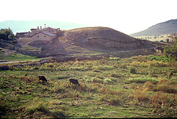
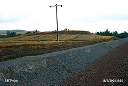
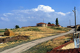
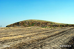
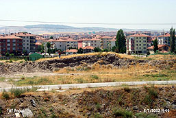
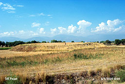
Altinekin (mound) (Konya/Altinekin): The northwestern section of this mound has been razed to construct the asphalt roadway that leads to Altınekin county. Dirt roads adorn most of its slopes. A kindergarten sits on the northern slope (to left of the picture). A number of houses built right on it complete the destruction. |
 |
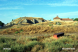
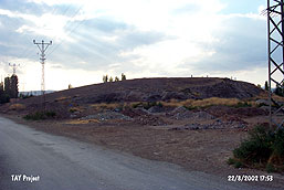
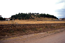
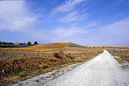
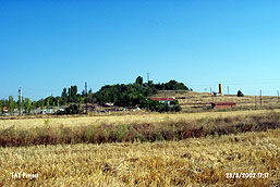
Akçasehir (mound) (Karaman/Akçasehir): A Chalcolithic era settlement dating back to 7000 years. It has managed to resist the assault of agricultural and construction activities to a degree. Nevertheless, a road runs through its western section and it is poked with numerous treasure hunter digs. |
 |
Alibey (mound) (Konya/Merkez): Alibey Mound township dwellings surround the slopes of this 7000 year old Chalcolithic settlement. Although not in use, an old water tower as well as dirt roads and power poles cover it. The rest is handled by (!) planted trees. |
 |
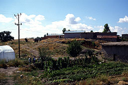
Ali Dede/Yeniyol (mound) (Eskisehir/Alpu): This 5000 year old EBA settlement is now used as a cemetery with a mosque on top. All of its slopes are surrounded by the cemetery’s stone wall and village dwellings. |
 |
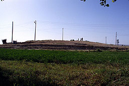
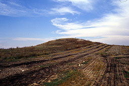
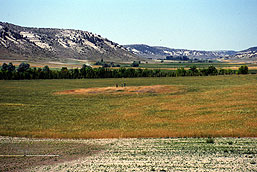
Barcin (mound) (Ankara/Ayas): This EBA mound is under heavy agricultural activity especially intensive on the northeastern section. The remains of an abandoned contemporary structure sits on its southern slope. |
 |
Bitik Hoyuk (mound) (Ankara/Kazan): Now mostly destroyed, this mound is about 42 km northwest of Ankara and under the Bitik village. The 1942 excavation of R.O. Arik had discovered layers belonging to Classical Period, Phrygian, Hittite, Copper and Early Bronze eras. |
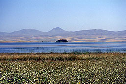 |
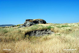
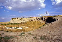
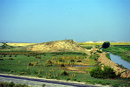
Buyuk Hoyuk (Ankara) (mound) (Ankara/Evren): This little island protruding from the water is actually a 7000 year old Chalcolithic era mound. It was submerged 35 years ago by the Hirfanli dam. It connects to the surrounding land when water levels drop. Water erosion is slowly but relentlessly eating it away. |
 |
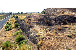
Çariklar (mound) (Konya/Meram): The road that leads to Çariklar town cuts through this EBA mound. It is also scarred by earth removals, telephone poles, partial agriculture and two 17x15 meters holes dug by treasure hunters. |
 |
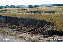
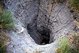
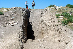
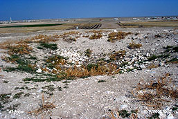
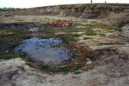
Çayir Hoyuk (mound) (Eskisehir/Çifteler): The slopes are under agriculture. This mound of 140m x 8m sports the largest illicitly dug hole that the TAY team has observed to date... |
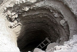 |
...4 meters in diameter and 11.2 meters in depth (!). That means the treasure hunters have managed to reach down below the main layer of soil. The ladder was still there. The earth removed during the dig is spread around the mound. |
 |
Çaykoz (mound) (Eskisehir/Sivrihisar): This 5000 year old EBA mound is on top of a rocky hill. Treasure hunters that have settled in the region have almost completely destroyed it by razing it right through its center north-to-south with the pretext of mining. |
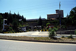 |
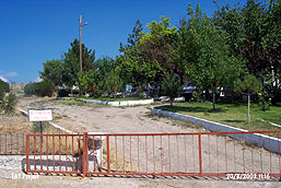
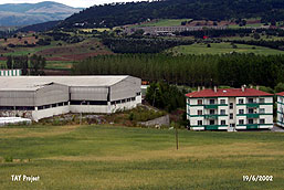
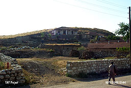
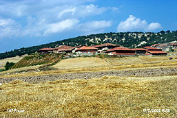
Çengeltepe (mound) (Yozgat/Merkez): It may seem odd that you see a brewery in this picture. However this is the site of a 5000 year old EBA mound that was documented 35 years ago. To add insult to injury, the management of the brewery which is governed by the state monopoly. |
 |
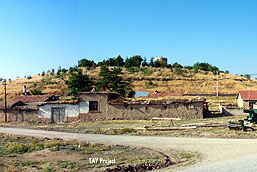
Çobankaya (mound) (Konya/Ilgin): This Chalcolithic era mound is partially under Çobankaya village dwellings. The slopes of the mound have been razed by earth removal. The removed earth is used in village constructions. |
 |
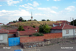
Çokumagil (mound) (Yozgat/Bagazliyan): This mound dating back 7000 years is under the Esentepe village. Although early researchers had documented the mound as 170 meters in diameter and 14 meters in height, it is almost non-existent today. The destruction is complete with road and dwelling construction. |
 |
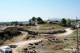
Eksile/Çataoren (mound) (Konya/Akoren): The mound is under the Hoyuk (mound) village. All of its archaeological structure is destroyed by dwelling construction. The village sewage is channeled into a deep hole dug on top of the mound. There are also a number of treasure hunter holes. The constructions that have begun during 1970s used the earth removed moved from the mound. 5000 years’ worth of soil and cultural residue is now scattered all around the village. |
 |
Eldes/Nodalar Hoyuk (mound) (Konya/Ilgin): Chalcolithic and EBA settlement, this mound is continually destroyed by agriculture. It also has a number of treasure hunter holes. |
 |
Ertugrul (mound) (Konya/Sarayonu): The slopes of this mound is systematically razed to enlarge crop growing land. The northwestern slope is covered by woods and there is a treasure hunter hole, 8 meters deep, on top. |
 |
Evderesi (mound) (Konya/Karatay): This EBA mound was first assaulted by earth removal, then turned into a dumping ground... |
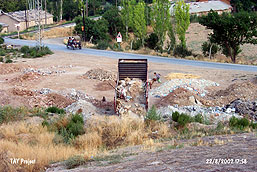 |
...You can see this activity in progress in the picture. The southeastern slope is razed off for road construction and a house is erected on it. |
 |
Hatip Hoyuk (mound) (Konya/Hatip): This Neolithic era settlement dating back 9000 years is under intense destruction. A dirt road is constructed on the western slope. Earth is removed from northern sections. Houses are constructed on the eastern slope and... |
 |
...two holes, one 10 meters deep, are dug on top by treasure hunters. |
 |
Hatunsaray (mound) (Konya/Meram): This EBA is ‘protected’ under the Forestry Service complex, iron gates, cobble stone pathways, newly planted trees, residence of the administrator and all… Right on top of the mound there is a rectangular pond constructed as part of a park that was planned by the municipality but never finished due to land dispute between it and the Forestry Service. |
 |
Ilisira (mound) (Karaman/Merkez): Surrounded by walls, this mound is terraced to plant trees. There is a recreational park on top of it with a pond, water tank and other constructions. An asphalt road runs from its skirts to the park on top. It bares numerous holes some reaching to 2 meters in depth. |
 |
Isgalaman Çingen Hoyuk (mound) (Konya/Karatay): The skirts of this EBA mound have been sacrificed to construction. A depot on its southeast, apartment building complex on its east, a mosque and farm land on its north and another apartment building construction on Yazicioglu street on its west… Its soil is removed and surface is poked with holes. |
 |
Kalkanli (mound) (Eskisehir/Merkez): Construction still continues on this 9000 year old Neolithic era mound. Kalkanli village dwellings and roads that cut through it contribute to its destruction. |
 |
Karacasar Hoyugu (mound) (Nevsehir/Gulsehir): The 5000 years old mound is used as a recreational park. Karacaşar village dwellings occupy most of it. There is also a power transformer on it as well as a planned water tower to come. |
 |
Karahoyuk I [Konya] (mound) (Konya/Merkez): Excavation had begun in 1953 and lasted through 1966 on this mound that is documented as one of the largest mounds in Central Anatolia. Today parts of it is razed off to construct a dirt road and most of it is used as garbage dump. |
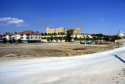 |
Karaman Hoyuk (mound) (Karaman/Merkez): This is an EBA settlement within the Karaman city limits. Karaman castle is constructed on top of the mound. Surrounding the mound are concrete roads, recreational parks and restaurants. Whatever remains of it is covered by trees. |
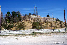 |
Karapinar I (mound) (Konya/Karapinar): The northern section of this mound that is encircled by barbed wires and walls is used as the Ali Tepe Recreational Park. It also has TV transmitters, cell phone hubs and power transformers on it. |
 |
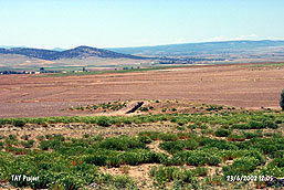
Karasevinç (mound) (Konya/Aksehir): All of the surface of this 7000 years old calcholitic era mound is opened for agriculture. Especially the eastern slope is heavily damaged by farming. |
 |
Karayavsan (mound) (Ankara/Polatli): The original structure of this mound that was excavated in 1965 is almost completely destroyed. Karayavsan village dwellings are constructed mostly by earth removed from this mound. Southeastern slope is terraced. It is poked by numerous illicit digs. |
 |
Kokez Hoyuk (mound) (Konya/Kadinhani): This mound, originally documented as 50 meters in height and 500 meters in diameter, has lost its entire northern slope to a road. Another section is under farming. It bares the scars of over 10 illicitly dug holes. |
 |
Konya Hoyuk [East] (mound) (Konya/Karatay): This mound is within the Karatay county. Holes to plant trees and irrigation channels cover its top. Earth is removed from the eastern section. Southwestern section is converted into a parking lot. A road that cuts through it in the east-west direction completes the destruction. |
 |
Kuçuk Hoyuk I (mound) (Karaman Merkez): The mound that is reduced down to a mere half meter was used as an apple orchard. After the intervention of the local museum the orchard activities have been stopped but not soon enough… |
 |
Kuçuk Hoyuk ve Mezarligi (mound and cemeteries) (Bilecik/Merkez): The slopes of this mound is occupied by Toprak Ceramics Plant residences. In 1988 the plant added a depot on it too. The cemetery that was part of the mound is completely destroyed. |
 |
Kulahli (mound) (Eskisehir/Mahmudiye): This Chalcolithic era mound of 7000 years has been subjected to intensive farming. Southern slope is flattened and annexed to the field next to it... |
 |
...Besides, there is a disturbance -a cut as a result of an illicit dig- about 4 m deep, 3 m wide and 25 m long from the highest point of the mound down to the plain level. |
 |
Kumluktepe (mound) (Kayseri/Incesu): This 9000 years old Neolithic era mound is damaged extensively by farming. The mound is also disfigured beyond recognition by the east-westerly fracture left from illicit excavations. |
 |
Mahmuthisari (mound) (Konya/Ilgin): The Chalcolithic and EBA mound is now at the center of Mahmuthisar village. Its slopes are razed to open roads, dwellings occupy the top and a cemetery lies on its southeastern section. |
 |
Maluyuk (mound) (Eskisehir/Alpu): Most of the height of this mound is lost due to farming. Numerous illicitly dug holes exist on it. Farming goes on relentlessly. Shortly there will be nothing left of it… |
 |
Nazir/Nadir (mound) (Konya/Aksehir): The 7000 years old calcholitic era mound is subjected to intensive damage due to farming. Half of it is razed to create farm land. |
 |
Okçu I (mound) (Konya/Çumra): All of the slopes of this Calcholitic and EBA mound are razed to open farm land. A number of treasure hunter holes exists on it. Roads cut through its skirt. Northeastern slope is used as dumping ground. We think we observed all forms of destructive activity here… |
 |
Osmancık Hoyuk (mound) (Konya/Kadinhani): All of it is under farming. Farming has eaten away almost all of its southeastern section as well as the road that runs to Kadinhani. One of its slopes is used as a cemetery. |
 |
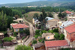
Pasali (mound) (Nevsehir/Avanos): This Chalcolithic era mound is surrounded by the dwellings of Pasali village. Its slopes are razed down for house constructions. Some constructions are still in progress. Widespread damage due to urbanization is all too clear here. |
 |
Polatli (mound) (Ankara/Polatli): This EBA mound was first documented in 1949. It measures 25 meters in height and 200 meters in diameter. Its circumference is razed to construct a school, a library and public training center buildings. County roads cut through its skirts. |
 |
Sincan (mound) (Ankara/Sincan): This 7000 years old mound is almost completely destroyed. Its surface is scattered, skirts razed and soil removed. It is used as a garbage dump. It bares the scars of numerous holes. A road cuts through northeastern slope. It is almost completely gone… |
 |
Sirçali/Çumra (mound) (Konya/Çumra): This rather large mound is utilized in various ways! We have observed all forms of archaeological destruction here. There is a municipality construction site on it. A dirt road runs on top. There is a recreational area that belongs to the municipality with a parking lot, an outdoors café and a kindergarten on it. A section is covered by trees. This site is a perfect case that samples a wide variety of archaeological destruction in Turkey. |
 |
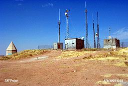
Sizma Hoyuk (mound) (Konya/Selçuklu): This EBA mound is now occupied by power poles, TV transmitters and cell phone hubs. Excavations done in 1920s document that this settlement was a goddess cult center in Antique ages. Presently it bares treasure hunters digs on top and dwellings on its slopes. |
 |
Tavsançali (mound) (Konya/Cihanbeyli): Approximately 30 meters of this mound’s northwestern section is missing due to earth removal. A similar situation exists on its eastern section. Remainder is serving as a platform for billboards. |
 |
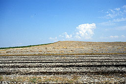
Tombaktepe (mound) (Konya/Aksehir): All the skirts of this 7000 years old calcholitic era have been razed down. It is flattened and opened to farming. Another Central Anatolia classic (!)… |
 |
Tosun Hoyuk (mound) (Aksaray/Eskil): The northern slope’s soil is removed, its skirts are subjected to extensive illicit digging. There is a 9 meters wide treasure hunter hole on it. |
 |
Tuglu Hoyuk (mound) (Çorum/Ugurludag): This mound is within the Tuglu village. Damage due to construction is rampant especially on its northeastern section. It is surrounded by walls and has a temporary cemetery on it. Eastern slope is razed down to build a dirt road. |
 |
Turbe II (mound) (Aksaray/Merkez): This EBA mound is located at the highest elevation of Ervah cemetery. It holds TV transmitters, cell phone hubs and the tomb of Kiliçarslan II. Aside from the massive damage on the mound, even the tomb is assaulted by treasure hunters. |
 |
Tuzla Hoyuk (mound) (Çorum/Ugurludag): The 5000 years old EBA mound is razed down from the southeast for road construction and from the northwest to build an irrigation channel. Its soil is also removed. Perhaps they did not realize that this was a cultural site! |
 |
Yorukmezari (mound) (Konya/Aksehir): The 9000 years old Neolithic era mound is subjected to extensive farming damage. A dirt road cuts right through its center. |
 |
Yukari Maltepe Hoyuk (mound) (Çorum/Iskilip): This EBA mound is now under the Leveler village. The west of it is razed off to build a dirt road, the southern slopes are damaged by farming and dwellings. |
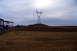 |
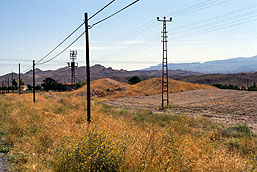
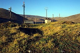
Yukari Sogutonu I (mound) (Eskisehir/Merkez): The 7000 years old mound is mostly damaged by high voltage power tower # GS-154. Its skirts are razed for farming. The southeastern section is damaged by house constructions. |
 |
Yunak Hoyuk (mound) (Konya/Kulu): This mound was documented to be 210 meters in diameter by early researchers. Today still ongoing extensive soil removal has left it beyond recognition. |
|
|
|
 Tanindi, O. - S. Okan et al., 2003, Archaeological Destruction in Turkey, Year 2002 Preliminary Report – Central Anatolia Region, TAY Project - Scientific Reports Series 13/Eng, ISBN 975-6637-12-9, Istanbul. Tanindi, O. - S. Okan et al., 2003, Archaeological Destruction in Turkey, Year 2002 Preliminary Report – Central Anatolia Region, TAY Project - Scientific Reports Series 13/Eng, ISBN 975-6637-12-9, Istanbul.
|