| ©The Archaeological Settlements of Turkey - TAY Project | ||||||
|
|
||||||
Kayislar |
||||||
|
|
||||||
| Ages | Maps | Photos | ||||
| Neolithic Chalcolithic EBA |
 |
 |
||||
|
|
||||||
|
Type:
|
Mound | |||||
|
Altitude:
|
100 m | |||||
|
Diameter:
|
m- Direction: | |||||
|
|
||||||
|
Region:
|
Aegean | |||||
|
Province:
|
Manisa | |||||
|
District:
|
Saruhanli | |||||
|
Village:
|
Kayislar | |||||
|
|
||||||
|
Destruction :
|
Agriculture - Highways, roads, bridges etc. - Attention | |||||
|
|
||||||
|
TAYEx:
|
Visited - 13/9/2000 | |||||
|
|
||||||
|
Registration State:
|
For detailed registration information please refer to Turkish pages. | |||||
 |
||||||
| Location: This site lies northeast of the city of Manisa; northeast of the town of Saruhanli; approximately 400 km northeast of the village of Kayislar. It is possible to get to this site by taking the turnoff to Kayislar from the Manisa-Akhisar highway. |
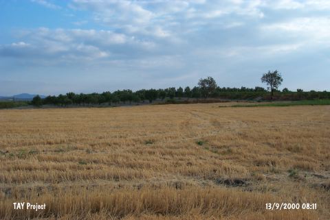
| Geography and Environment: The small mound; which lies on a low ridge; is oval in shape. It is 80 m long north-south; 50 m long east-west and 3-4 m high. Today the surface of the mound is cultivated. There is a dirt village road on the eastern side of the mound and a spring at the western foot of the mound. In 1965; when the site was surveyed; the area west of the mound was a swamp. |
| Destruction Details: The mound is severely damaged due to agricultural activities. There is a 1 m difference in the elevations of the two fields in the middle section [TAYEx 13.9.2000]. It was researched again by E. Akdeniz et al. in 2007 and found that it was entirely flattened [Akdeniz 2009:257]. |