| ©The Archaeological Settlements of Turkey - TAY Project | ||||||
|
|
||||||
KM 97 Domuztepe |
||||||
|
|
||||||
| Ages | Maps | Photos | ||||
| Neolithic Chalcolithic |
 |
 |
||||
|
|
||||||
|
Type:
|
Mound | |||||
|
Altitude:
|
550 m | |||||
|
Diameter:
|
m- Direction: | |||||
|
|
||||||
|
Region:
|
Mediterranean | |||||
|
Province:
|
Kahramanmaras | |||||
|
District:
|
Pazarcik | |||||
|
Village:
|
Emiroglu | |||||
|
|
||||||
|
Destruction :
|
Agriculture | |||||
|
|
||||||
|
TAYEx:
|
Visited - 6/8/2001 | |||||
|
|
||||||
|
Registration State:
|
Registered For detailed registration information please refer to Turkish pages. | |||||
 |
||||||
| Location: The mound lies in Emiroglu Village; southwest of Narli Sub-district; 32 km south-southeast of the centrum of Kahramanmaras. It is labeled KM 97 by Carter (KM being the abbreviation of Kahramanmaras). |
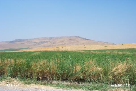
| Geography and Environment: The mound located on the east bank of Aksu River; in Maras Plain Ñan alluvial formation by the river springing out from Kürt MountainsÑ and is surrounded by rich fields convenient for agriculture and animal husbandry. It lies on the natural mountain-pass from north to southeast; in Maras Plain. Therefore it is in an area extremely convenient for settling. The ovoid mound is 12 m higher than the plain level and covers an area of 18 hectares. A series of cores was taken both on and off the site in 2004 and suggests that the area west of the site was a marsh or lake in prehistory [cat.une.edu.au/page/domuztepe 25.7.2006; 10:30]. |
| Destruction Details: The mound is completely cultivated. Soil has been removed from southeast skirt because of agricultural activities and top hill has been leveled [TAYEx 6.8.2001]. |