| ©The Archaeological Settlements of Turkey - TAY Project | ||||||
|
|
||||||
Kumocagi / Avariz |
||||||
|
|
||||||
| Ages | Maps | Photos | ||||
| Chalcolithic |
 |
 |
||||
|
|
||||||
|
Type:
|
Mound | |||||
|
Altitude:
|
-22 m | |||||
|
Diameter:
|
m- Direction: | |||||
|
|
||||||
|
Region:
|
Marmara | |||||
|
Province:
|
Edirne | |||||
|
District:
|
Merkez | |||||
|
Village:
|
Avariz | |||||
|
|
||||||
|
Destruction :
|
Mines/Quarries - Attention | |||||
|
|
||||||
|
TAYEx:
|
Visited - 13/6/2000 | |||||
|
|
||||||
|
Registration State:
|
For detailed registration information please refer to Turkish pages. | |||||
 |
||||||
| Location: The site lies approximately 8 km north of Edirne and 2 km south of Avariz (Havaris) Village. |
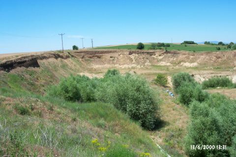
| Geography and Environment: The site lying on the west bank of Tunca River is dug for taking away sand and gravel and is again damaged by excavators for the same purpose on the east. The road of the mine passes from the south and southeast of the mound. The size of the site is not cited. |
| Destruction Details: The mound was seriously damaged by deep and wide mine dug for taking away sand. In the section of the mine; immediately beneath the surface soil; the cultural fill can be observed. The southern side of the settlement is cut by the road to the mine. A slight elevation near this road may indicate that the cultural fill continues beneath the road [TAYEx 13.6.2000]. |