| ©The Archaeological Settlements of Turkey - TAY Project | ||||||
|
|
||||||
Yarimburgaz Magarasi |
||||||
|
|
||||||
| Ages | Maps | Photos | ||||
| Palaeolithic/Epipalaeolithic Neolithic Chalcolithic 14C |
 |
 |
||||
|
|
||||||
|
Type:
|
Cave | |||||
|
Altitude:
|
20 m | |||||
|
Diameter:
|
m- Direction: | |||||
|
|
||||||
|
Region:
|
Marmara | |||||
|
Province:
|
Istanbul | |||||
|
District:
|
Küçükçekmece | |||||
|
Village:
|
Altinsehir | |||||
|
|
||||||
|
Destruction :
|
Illicit Digging - Contemporary Settlements - Attention | |||||
|
|
||||||
|
TAYEx:
|
Visited - 27/5/2000 | |||||
|
|
||||||
|
Registration State:
|
Registered For detailed registration information please refer to Turkish pages. | |||||
 |
||||||
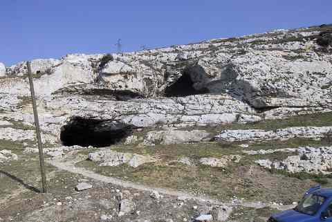
| Location: This double mouthed cave lies approximately 22 km northwest of the city of Istanbul in the district of Küçük Çekmece; about 1.5 km north of the northern shore of the Küçük Çekmece Lake. It is 1 km north of the shantytown of Altinsehir (now a district of Istanbul); northeast of the road from the village of Samlar; which is north of Altinsehir; to Kayabasi; on the east bank of the Sazlidere (Azatli) River which empties into the Küçük Çekmece Lake. Because the cave has two mouths; the site is also referred to in the plural as the Yarimburgaz Caves. |
| Geography and Environment: The Yarimburgaz Cave; created by the erosive power of a subterranean river on the western flank of a hilly limestone formation facing the Sazlidere River; has two interconnected chambers differing in elevation; size and shape. Each chamber has its own entryway. The caves are between 11-18 m above the Marmara sea-level. The upper section of the cave; oriented roughly northeast-southeast (Upper Cave / Gallery B) appears to be a large hall; approximately 15 by 52 m and presently 10 m high. It is likely that parts of the cave were leveled and that the space was used as a church in Byzantine times. Holes in the cave walls indicate that the cave also supported a tile-paved loft. It is certain that the monasterial structures outside the cave are associated with this occupation phase. To reach the lower chamber (Lower Cave/Gallery A) from the upper cave; it is necessary to descend an incline near the mouth of the cave. What appears to be a gallery develops into tunnel shaped meandering passages with occasional large halls. In contrast to the upper chamber; which quickly comes to an end; the lower chamber continues for approximately 600 m. 240 m beyond the entrance of the lower cave; the passage forks into two. The right branch continues further than the left; funneling to a narrow impassable corridor. The formation of the cave is probably related to the valley running perpendicular to the Sazlidere River. In the Lower Palaeolithic; this wadi may have been an extension of the cave. Bedrock was reached in the Yarimburgaz excavations near the entrance only. Consequently; the original height of the cave chamber could not be determined. The formation of the cave is believed to be very old. It is further assumed that the environmental conditions in the Palaeolithic times were very different than today. Due to its proximity to the Istanbul city center; the Yarimburgaz Caves have attracted the attention of picnickers; treasure hunters and other illegal explorers; speleologists and amateur archaeologists. This increased after Kansu and Kökten began excavation. Perhaps the foremost reason for this interest is the fact that the caves were used as a church in their final phases. The caves have also been used by movie and television makers as a film setting. The Ministry of Culture has neglected the caves by allowing a grader into the cave to level the ground for a mushroom farm. In order to stop these destructive activities performed by various people; organizations and especially by the treasure hunters; the caves have been closed off by iron bars since the Arsebük excavations. This has decreased the amount of damage. |
| Destruction Details: In the Upper Cave; pits of treasure hunters were observed in the section of the church that is close to the mouth and to the southwest of the entrance. As a result of the illicit diggings; a wall made of hewn stones has become visible. The wall runs along the passageway between the Upper and Lower caves. The walls of the chamber tomb on the cave was also destroyed. The contemporary settlement in the area is continuing towards the cave [TAYEx 27.5.2000]. |