


|
|
TAYEx Byzantine Marmara Expedition
Completed...
(April-September 2008)
|
 |
11 Provinces
10.441 miles
in 6 mounts
467 Buildings / Sites
(Palaces, Fortresses, Fortifications, Bridges, Cisterns, Water Networks, Aqueducts, Hagiasmas, Monuments, Churches, Monasteries, Grave Buildings, Houses, Workshops...)
16.126 (36.6 Gb) digital photographs
165 Gb video
TAYEx TV (2008)
|
First Step of TAYEx is finished...
(2000-04)
7 regions
75 cities
57,058 miles
in 5 years
Over 2.800 settlements
21,567 (14 Gb) digital photographs
11,102 analog slides
151 hours of video
Updates of the databases completed...
Time for fieldwork
Of the Byzantine Period,
The Cave Inventory of Turkey
And other periods
Has come!
|

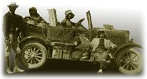
Photo: Greg Bartley |
A 79-year-old dream comes true...*
-
- *"(...) von der Osten, student of Professor M.J. Breasted, was of the greatest assistance in this project. This young German scholar, the worthy successor of Texier and the great W. M. Ramsay, formulated the initial Anatolian study plans. Even though the proposal of this young, foreign student faced extreme criticism, Breasted used his influence to facilitate the applications' acceptance by the Oriental Institute.
The aims of von der Osten's Anatolian study programme can be summarised as follows: to conduct extensive archaeological surveys; to revisit sites explored by previous travellers; to investigate their reports and reconfirm their information; to detail what had previously been overlooked; to visit and document unrecorded sites, ruins and monuments. In short, to create an inventory of all archaeological data and compare these new findings with previous writings and published information so to establish an accepted interpretation (...)"
|
(From von der Osten, Exploration in Hittite Asia Minor, 1926, no.8, as quoted by Remzi Oguz Arik in "Anadolu Arkeologya Tarihinde Alisar Hafriyati", Turk Tarih ve Arkeologya ve Etnografya Dergisi, July 1933, no.1, Istanbul])
Photo: The expedition at Imatli (Turkey, 1926) - Explorations in Central Anatolia Seasons of 1926
A few Q & A about TAYEx:
-
- -What is the Objective of the TAY Expedition?
The TAY Expedition had three main objectives:
1. The verification of archaeological reports published to date;
2. The documentation of current state of finds-locations and sites (such as mounds, caves, rock shelters, flat settlements, tumuli, monuments, etc.)
3. The building of a visual archaeological archive for Turkey
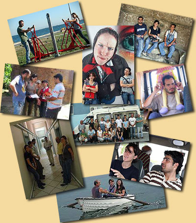
A team of specialists inclusive of archaeologists, geologists, surveyors, photographers and filmmaking teams have now systematically surveyed both Anatolia and Thrace. Surveyed and excavated sites have also been inspected using a range of available technologies. In addition, from the Palaeolithic through to the Early Bronze Age, the current state of each site starting and the extent of destruction have been documented.
With these objectives continuously at mind,
In five years
We drove 57,085 miles
Carrying a team of around a hundred
We explored cities, towns and villages throughout the whole of Turkey
Documenting
2800+ archaeological settlements, locating coordinates, measuring and reporting, noting any destruction, and distributing information to the public.
Whilst collecting
- 21,567 (14 GB) digital photographs
- 11,102 analogue transparencies
- 151 hours of film.
-What were the Geographic Limits of the Expedition?
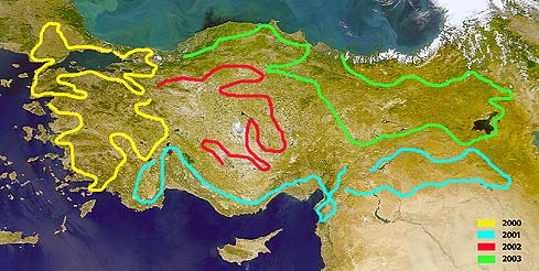
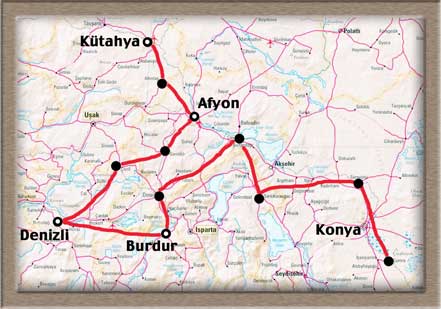
This particular field project included all of Turkey and has been conducted in 7 regions (Marmara, Aegean, South-eastern Anatolia, Mediterranean, Central Anatolia, Black Sea, and Eastern Anatolia) in accordance with the structure of the TAY database. The 5-year plan for TAYEx was as follows:
- June-July 2000: Marmara
|
- September-October 2000: Aegean
|
- June-July 2001: Mediterranean
|
- September-October 2001: SE Anatolia
|
- June-October 2002: Central Anatolia
|
|
- June-July 2003: Black Sea
|
.August-October 2003: Eastern Anatolia |
- July-August 2004: E Aegean - W Central Anatolia Route
|
|
| April-November 2008: Marmara (Byzantine Period - Marmara) |
|
|
|
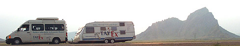
- -What were the Transportation and Camping Facilities?
The expedition vehicles have been designed specially by the team members. The 'TAYmobile' is a 7 meter-long caravan with 3 sets of bunk beds, a study area, a kitchen and a toilet, pulled by the 'TAYvan', which is again a modified vehicle specifically made for its purpose. The caravan detaches from the van in daytime to allow off-road exploration. The team camps in the TAYmobile.
-What was the Fieldwork?
All archaeological sites, monuments and find-spots in Turkey were visited one by one. The fieldwork included the measuring of coordinates, altitude, site dimensions, mapping, photographing (analogue and digital) and filming.
-Who were the Team Members?
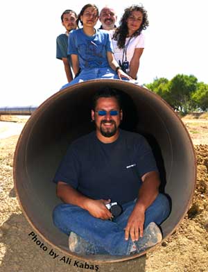
TAYEx was made of different teams for each region being surveyed. Each team included one team leader, two archaeologists one IT specialist, one photographer, and where necessary, a surveyor and a geologist. There was also a filmmaking team following suit of the expedition team.
-How is the TAYEx Data be Published?
The process of TAYEx data publishing is now available as a link through this website (TAYEx TV: only available in Turkish). Through this page, you may learn where we were and what we were doing. The results of the expedition are accessible to TAY users through paper-based and electronic updates. Also, the Project publishes a document titled "Turkey's Archaeological Destruction Report" annually.
|
 .. .. |
TAY Project . Kuruçesme Cad. 67/B
34345 Kuruçesme Istanbul Turkey
Tel: +90 (212) 265 7858 - Fax: +90 (212) 287 1298
e.mail: info@tayproject.org |
| Copyright©1998 TAY Project |
|
|
